Haulover Inlet’s got a reputation that’s hard to ignore, and figuring out why is Haulover Inlet so dangerous is crucial if you’re planning to run it. Those viral videos of boats getting absolutely hammered look crazy, but there’s real science behind the chaos—shifting sandbars that relocate overnight, wave physics that create monsters out of nowhere, and tidal currents that can hit 6 knots. When you throw in wind-against-tide scenarios and the inlet’s funnel effect, you’ve got a recipe for some seriously gnarly conditions. Let’s dive into what makes this passage so notorious and how you can navigate it like a pro.
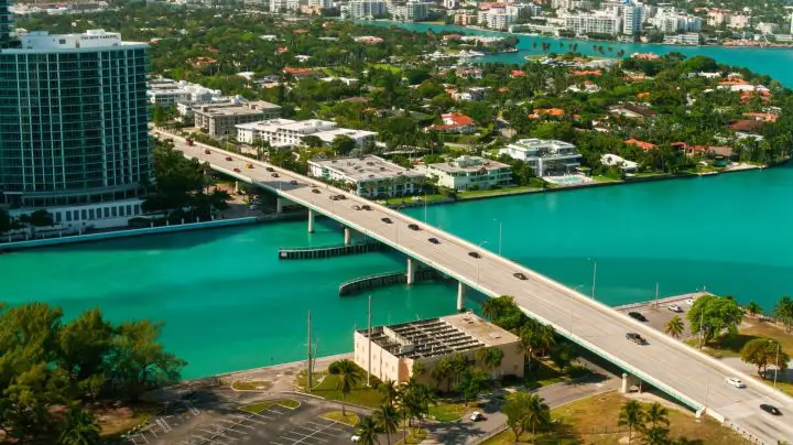
Table of Contents
- Where Is Haulover Inlet?
- The Natural Geography Behind the Danger
- Weather & Ocean Conditions
- Boat Traffic & Human Factors
- Physics of the Waves
- Local Efforts to Improve Safety
- Tips for Boaters
- Don’t Let Haulover Catch You Off Guard
- FAQs – Why Is Haulover Inlet So Dangerous?
Where Is Haulover Inlet?
Sitting right between Bal Harbour and Sunny Isles Beach, Haulover Inlet carved its way into South Florida’s coastline back in 1925. Think of it as Miami’s nautical gateway—a man-made channel that bridges the northern tip of Biscayne Bay with the wide-open Atlantic. It’s roughly 15 miles north of Miami’s glittering skyline, making it the go-to passage for anyone cruising the northern Biscayne Bay area who wants ocean access without the long haul down to Government Cut.
You’ll find this waterway at Intracoastal Waterway Mile 1080—basically the only ocean outlet between Miami’s Government Cut to the south and Fort Lauderdale’s Port Everglades to the north. For boaters, that’s prime real estate. A fixed bridge spans overhead with 32 feet of clearance, so if you’re piloting anything taller, you’ll need to rethink your route. The 99-acre Haulover Park wraps around the inlet, giving you everything from marina facilities to Florida’s most famous clothing-optional beach.
Related: How Far is Cuba from Florida by Boat? And, Can You Cruise Cuba?
The Natural Geography Behind the Danger
Here’s where things get interesting—and treacherous. The inlet’s narrow design acts like a funnel, compressing massive volumes of water flowing between the bay and ocean into a tight space. It’s basic physics with high-stakes consequences.
The sandbars at Haulover don’t stay put—they’re constantly on the move. What’s a clear passage one day might be a boat-grounding hazard the next, which is why the Coast Guard has to relocate the channel markers regularly. The inlet’s average depth hovers around 14 feet in the marked channel, but venture outside those boundaries and you’re playing Russian roulette with your hull. Since Biscayne Bay is enormous, outgoing tides create massive pressure as all that water squeezes through Haulover’s narrow opening. Current speeds can hit 4 to 6 knots, which doesn’t sound dramatic until you realize that’s faster than most people jog. The shallow, uneven bottom causes wave shoaling—basically, waves get taller and steeper as they encounter shallower water. The inlet’s tight quarters amplify everything, creating turbulence that makes boat handling tricky even on relatively calm days.
Weather & Ocean Conditions
If Haulover’s geography loads the gun, weather pulls the trigger. This inlet’s got a front-row seat to whatever the Atlantic wants to throw at it, and the Atlantic’s got quite an arm.
When easterly winds blow onshore—especially the notorious east winds common along this stretch of coast—they collide head-on with outgoing tides. That wind-against-tide scenario is every captain’s nightmare. These conditions can create huge waves in the navigable waterway even when the surrounding ocean looks relatively tame. South Florida’s weather can flip on a dime, with summer thunderstorms materializing out of nowhere and winter cold fronts pushing in with surprising punch.
Key weather factors that make Haulover dangerous:
- Marine forecasts regularly show wave heights that can occasionally hit 9 feet during rougher conditions
- Breaking waves and swells over 10 feet high are common during storms
- Proximity to the Gulf Stream influences regional weather patterns, causing forecasts to change rapidly
- Afternoon thunderstorms in summer can appear with little warning
- Strong northeast winds create particularly hazardous conditions
Boat Traffic & Human Factors
Nature sets the stage, but humans often steal the show—and not in a good way. Social media channels filming at Haulover have turned this inlet into a viral sensation, with camera operators from pages like Boat Zone and Wavy Boats setting up shop on the jetty, capturing every stuffed bow and airborne boat. The Coast Guard has raised serious concerns about recreational boaters who often don’t know what they don’t know. Picture this: bow riders with kids clutching the rail without life jackets, pontoon boats submarining into waves, passengers getting tossed like rag dolls. High boat traffic volumes create a chaotic environment requiring heightened situational awareness. You’re not just battling waves and current—you’re also dodging jet skis, fishing boats that stop suddenly, and inexperienced operators. Sometimes, the most dangerous element in the Haulover Inlet is fellow boaters.
Physics of the Waves
Ever wonder why some waves at Haulover seem to come out of nowhere, hitting harder than they should? There’s actual science behind the chaos.
As waves move from deep water into the inlet’s shallow areas, they undergo shoaling—the wave energy gets compressed vertically, making waves taller and steeper. It’s like squeezing a water balloon from the bottom—all that energy has to go somewhere. The waves don’t just get bigger; they become unstable and prone to breaking unpredictably. When waves hit the rocks and jetties lining the inlet, they bounce back—that’s wave reflection in action. These reflected waves then collide with incoming waves, creating interference patterns that can form rogue waves significantly larger than the surrounding sea state.
Key wave physics at Haulover:
- A shallow seabed creates uneven bottom topography with sudden depth changes that disrupt wave patterns
- Enormous pressure as Biscayne Bay empties through the inlet interacts with the jetty walls with considerable force
- Compressed water flow creates pressure zones where waves stack up higher than in open water
- The inlet manufactures its own wave conditions that can be far worse than ocean conditions just outside
Related: 9 Best Liveaboard Catamaran: Sail Away and Explore the World in Style!
Local Efforts to Improve Safety
The good news? Authorities aren’t just standing by watching boats get pummeled. The U.S. Army Corps of Engineers has conducted maintenance dredging to deepen the navigable waterways, with projects deepening areas by about three to six feet. The catch? Sand continues washing back in and reaccumulates in about five years, so it’s an ongoing battle. Recent projects have moved sand from the infamous Haulover Sandbar to replenish eroding beaches in Bal Harbour, serving double duty.
Miami-Dade Fire Rescue’s Marine Services Bureau operates two fireboats that patrol county waterways 24/7, ready to respond within seconds when things go wrong. The Ocean Rescue Bureau stations over 90 lifeguards at Haulover Beach, and they respond to inlet emergencies, too. Florida Fish and Wildlife Conservation Commission officers patrol the area regularly. Coast Guard recreational boating safety specialists have been actively working to educate the public about inlet dangers, emphasizing that proper seamanship training can prevent most accidents. While there aren’t elaborate warning signs at Haulover, the inlet’s reputation itself serves as a warning.
Tips for Boaters
Ready to run Haulover? Here’s how to dramatically improve your odds of making it through in one piece.
Navigate during slack tide—that brief period between high and low tide when water movement is minimal. The half-hour slack tide window is often the only time conditions calm down. Absolutely avoid the inlet during outgoing tide with strong easterly winds—that’s when conditions go from challenging to potentially catastrophic. Before entering, take time to study the wave pattern and identify areas with bigger waves versus smaller ones. Watch what experienced captains do and follow their lead.
Essential navigation tips:
- Check tide tables religiously before heading out
- Always check marine forecasts from reliable sources like NOAA before departing
- If it’s rolling big in the middle of the channel, hug the north jetty—it’s usually smoother there
- If you see people sitting in lawn chairs in the water ahead, don’t go that way—they’re on a sandbar
- Pay close attention to wind conditions—when winds exceed 15-20 knots from the east, think twice
- If waves are forecast over 5-6 feet in the ocean during outgoing tide, those can turn into 8-10 footers in the inlet
- Download boating apps that provide real-time weather, wave height, and tide information
- Travel during daylight hours when you can see conditions clearly
- Ensure everyone onboard wears proper life jackets
- Maintain a safe speed and stay alert for other vessels
Sometimes the smartest navigation decision is staying at the dock. If conditions look sketchy or you’re unsure about your boat’s capabilities, there’s no shame in waiting for a better day.
Don’t Let Haulover Catch You Off Guard
Haulover Inlet’s deadly reputation isn’t hype—it’s physics, geography, and unpredictable weather colliding in a narrow channel. Shifting sandbars, 4-6 knot currents, and waves that can hit 10 feet during outgoing tides make this passage treacherous even for experienced captains. But you’ve got the knowledge now to navigate it safely. Time your transit during slack tide, check NOAA forecasts religiously, hug the north jetty when it’s rough, and recognize when conditions exceed your capabilities. The smartest captains know that sometimes staying docked is the bravest call. Respect the inlet, study the conditions, and never let ego override common sense. Haulover will be there tomorrow—make sure you are too.
FAQs – Why Is Haulover Inlet So Dangerous?
Why are the waves so rough at Haulover Inlet?
The waves at Haulover become rough due to a perfect storm of factors. The narrow inlet funnels massive tidal currents (4-6 knots) between Biscayne Bay and the Atlantic, while the shallow bottom causes wave shoaling—making waves steeper and taller. When easterly winds collide with outgoing tides, they create standing waves. Add in wave reflection off the jetties and shifting sandbars, and you’ve got conditions that can turn moderate ocean swells into 10-foot breakers right in the channel.
What is the deal with Haulover Inlet?
Haulover Inlet is Miami’s most infamous waterway—a man-made channel cut in 1925 between Bal Harbour and Sunny Isles Beach. It’s the only ocean access between Government Cut and Port Everglades, making it heavily trafficked but notoriously dangerous. The narrow passage creates intense tidal currents, shifting sandbars, and unpredictable waves that have turned it into a viral sensation. Social media channels capture boats getting hammered daily, but it’s the combination of geography, physics, and inexperienced operators that makes it truly treacherous.
How deep is the Haulover inlet?
Haulover Inlet maintains an average depth of around 14 feet in the marked navigation channel. However, depth varies significantly due to constant shoaling and shifting sandbars. The U.S. Army Corps of Engineers conducts maintenance dredging every few years, deepening areas by three to six feet, but sand continuously washes back in. Outside the marked channel, depths can be dangerously shallow—sometimes just a few feet—which is why staying within the buoys and following local knowledge is critical for safe passage.